The Willard Hackerman Map Collection is currently on display in the George Peabody Library and will remain open to the public until March 16.
Hackerman, a 1938 alumnus of the Whiting School of Engineering who died in 2014, was the president of the Whiting-Turner Contracting Company, which is responsible for constructing many buildings across Baltimore. These buildings included the National Aquarium and the Joseph Meyerhoff Symphony Hall. Hackerman’s family donated the map collection to the Sheridan Libraries in 2017.
Paul Espinosa, the curator of the Peabody Library, explained that once the libraries received the collection, exhibiting it was the natural next step.
“Often when the libraries receive a gift, we want to celebrate it,” Espinosa said.
The maps could not be displayed right away because the exhibit space was either booked or undergoing construction.
Once a date for the exhibit was settled, the curators of the exhibit discussed the pieces that should be displayed. According to Jim Gillispie, Geographic Information System (GIS) librarian and map curator, only about a third of the collection is in the exhibit.
“My colleagues and I argued back and forth until we chose what we believe is a good representative chunk of the whole collection,” Gillispie said.
In addition to maps, the exhibition also features printed views of Baltimore from the Harry N. Baetjer Collection of Historical Maps and Prints.
According to Espinosa, both the artistic value and the significance of the materials were considered in the selection process. At Hopkins, the maps are also used in georeferencing, or the process of using historical maps and GIS to mark certain locations on the map. Gillispie believes that this unique feature was one of the main reasons that Hackerman’s family decided to gift the Collection to Hopkins rather than selling it or giving it to a museum.
“We aren’t another museum, it is a live, active collection. The digital parts bring old maps alive,” Gillispie said.
Espinosa explained that the Peabody Library displays at least one exhibit a year. The Hackerman Collection will be on display until March.
The exhibit is divided into four main sections. One showcases Hackerman’s life, and another highlights Hackerman as a collector. The third section is dedicated to maps of the Chesapeake Bay. The fourth focuses on the growth and development of Baltimore. There is also a digital display of a story map of georeferencing.
The exhibit was meant to display the map collection, but the curators also wanted to show Hackerman’s connection to Hopkins.
“What makes this gift so interesting and important is not only the material, but also the fact that the benefactor was a Hopkins alumnus,” Espinosa said.
The exhibit includes information about Hackerman’s life and his undergraduate student file, which was taken from the Archives.
Viewers can see his one-page application to Hopkins from June 1935. His acceptance letter, dated a month after his application was submitted, is also on display. Alongside these documents and his official undergraduate photos, is a statue sculpted by Hackerman.
“By him giving it to Hopkins, it will remain in Baltimore for the rest of time. And so a very rare object like that is able to be preserved for us,” Espinosa said.
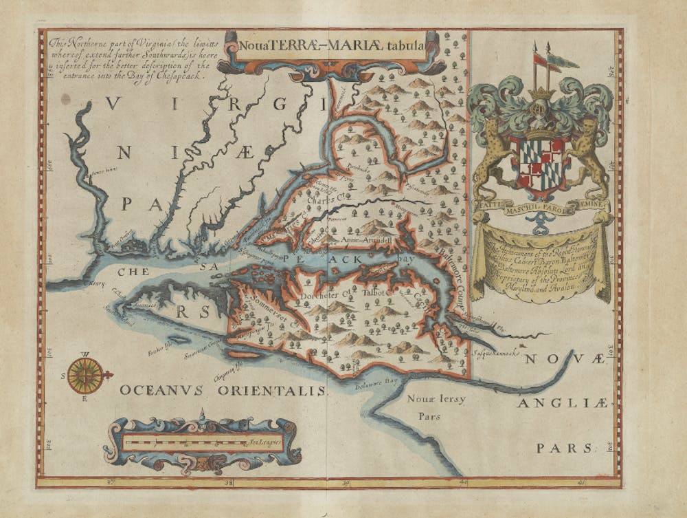
The third section of the exhibit is dedicated to maps of the Chesapeake, which were one of Hackerman’s main collecting interests. The maps are complemented with books and manuscripts from the Sheridan Libraries. For example, the 1632 Lord Baltimore Map of the Chesapeake is accompanied by the official charter granting the land to Lord Baltimore.
Earle Havens, the Nancy H. Hall Curator of Rare Books and Manuscripts, noted the exhibit shows the rapid expansion of Baltimore and the technological strides in map making.
“The Collection shows how dramatic the technology surrounding map making developed. The 17th and 18th century we saw a revolution in the accuracy and the geometric and mathematical sophistication in the way terrain, seas and rivers were represented,” Havens said.
According to Havens, this section is of particular interest not only because of its historical and artistic dimensions, but also because it allows viewers, especially students, to draw connections to their place in Baltimore.
“I noticed that the first thing that people did was to look for themselves. Where is my hometown? Where is my street in Baltimore? We get to see ourselves transported back centuries because we share the same geography,” Havens said. “Undergraduates should visit the rare book collection at Peabody because it is their collection.”